Emergency Response » Emergency Supplies » Unmanned Air Vehicles
Unmanned Air Vehicles
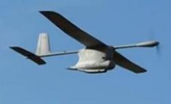
Disaster/post disaster aerial information assessment and security UAV
The Unmanned Air Vehicle Security & Intelligence is a sophisticated and highly reliable information gathering tool. Operational in most conditions and over both land and sea and can be utilised to collect various different forms of data via its state of the art sensors.
Operated in full automatic mode, the flight is pre programmed before take off for completely autonomous flight to ranges in excess of 80 Km. Utilising our own digital flight control system incorporating Global Positioning System (GPS) and Inertial Navigation System (INS) for navigation and controlling using the Tactical Control Station (TCS), this stem is one of the most capable post disaster information gathering systems available. The system can be quickly deployed and is configured for fully automatic operations, in both day and night time conditions.
A ‘quick-change’ mission pod system allows for multi-mission capability. It will capably assist in post Earthquake, Flood, Eruption, Landslide, Snowstorm and critical national infrastructure failure events and will also assist both Government and NGO efforts to establish security at refugee camps and on main supply routes.
Technical Information
| Wingspan: | 3.2m (10ft 6ins) |
| Wing Area: | 1.0m2 (10ft 8ins2) |
| Length: | 2.5m (8ft 2ins) |
| Height: | 0.45m (1ft 6ins) |
| Typical Weight: | >9.5kg (20.1lb) Max 20kg (44lb) |
| Construction: | Carbon-kevlar composite with Honeycomb Nomex |
| Power Unit: | Battery, rechargeable |
| Endurance: | >120 mins (according to flight parameters) |
| Power Plant: | UTSL single electric motor |
| Speed Range: | 13-38m/s (48-140kph) (30-87mph) (26-75kt) |
| Launch: | Man portable lightweight catapult (not rubber) |
| Payload Capabilities: | CCD Camera (Sony) - Stabilised Thermal Imager - Stabliised Multi/Hyper Spectral Camera Fixed Forward Looking CCD Camera "Quick-change" mission pod Customer specified mission equipment |
System Performance Information
| Operating Range: | >80km (50 miles), extendable |
| Surveillance Details: | Real time surveillance to >80km (50 miles), extendable |
| Command & Control: | Spread spectrum frequency hopping |
| Video Link/Format: | Sophisticated COFDM, IP output, encrypted - according to customer requirements |
| Altitude: | Max > 3000m (9,800ft) Min < 40m (130ft) (typically) |
| Recovery: | Autonomous skid landing with emergency recovery system (air regs) |
| Tracking: | GPS/INS with full telemetry, including flight data recording etc. Fully automatic pre-programmed flight with auto landing. |
Emergency Response
At AMTC we can provide you with the necessary infrastructure, equipment and disaster management tools and solutions in the event of national and international crisis and emergency response.
Infrastructure, Oil & Gas
Ensure you have a fully operational infrastructure and supply network in place to ensure your recovery plans are effectively implemented with AMTC's range of products and services including oil and gas solutions.
Homeland Security
Provision of professional homeland security equipment and communications solutions including infrared, personal and large-scale scanning devices, CCTV and recording systems for use in the airports, police etc.
Communications
Specialists in integrated radio and telecommunications systems from system integration to wireless network solutions. We also provide product hire and sales alongside a radio repair and maintenance workshop.
Agriculture & Water
Establish a sustainable, independent and effective food supply chain with farm machinery products and food production design and project management services from AMTC.
Medical
At AMTC we specialise in trading and distributing medical products, focused on generic medicine, medical supplies, disposables and tests. We are committed to offer high quality products and affordable medicine.